Rattanakiri Province: Things To Know Before Visit
Rattanakiri Province situated in the northeastern highlands of Cambodia, features a variety of stunning landscapes and terrains, making it a perfect spot for those who love nature, jungle trekking, and mountain climbing. Although it has a low population density, Ratanakiri offers a unique opportunity to experience the rich culture of Cambodia’s ethnic minorities and their deep connection to the natural world.
General Information of Rattanakiri Province
Ratanakiri Province located in northeastern Cambodia, borders Laos, Vietnam, Mondulkiri, and Stung Treng. This rugged province has a 70% ethnic minority population known as the “Chunchiet.” Once off the tourist radar until 2002, Ratanakiri is now gaining attention for its remote beauty.
Traveling beyond the capital, Banlung, reveals minimal tourist crowds, making it a hidden gem worth exploring. The name “Ratanakiri” means “place of gems and mountains,” derived from Sanskrit.
Banlung, about 365 miles from Phnom Penh, is a vibrant town with a wild western vibe, featuring red laterite roads and a bustling market. Other towns like Lomphat, Ta Veng, and Voen Sai also dot the province. Ratanakiri attracts thousands of tourists each year, especially those seeking authentic experiences, rich ethnic heritage, and diverse wildlife, with thriving ecotourism supported by its lush landscapes and indigenous communities.
Ethnic Cambodians make up only 10-20% of the country’s population. Near Banlung, remnants of an ancient volcano have created a stunning crystal-clear lake and ancient lava fields. Nature enthusiasts can explore beautiful waterfalls, clear rivers, and lush jungles, with options for low-impact trips to nearby villages.
In Banlung, you may meet a few foreigners who can share current tour options, as the area is not heavily visited. Hill tribe communities further out may be surprised by your presence due to their limited exposure to tourists.
Yeak Laom Volcano Lake, located close to town, is ideal for swimming, picnicking, and hiking around the crater rim. With a depth of 48 meters and a diameter of 750 meters, the lake features exceptionally clear water and a small local museum. In 1995, a 5,000-hectare protected area was designated around the lake, supported by international organizations for resource management.
A short walk from the Cultural and Environmental Centre offers insights into the region’s history, showcasing local hill tribe tools and crafts for sale, including musical instruments and clothing. Visitors can explore a nature trail around the crater rim. The site features remnants of King Sihanouk’s chalet, destroyed during the 1970s war, and locations of former gun emplacements.
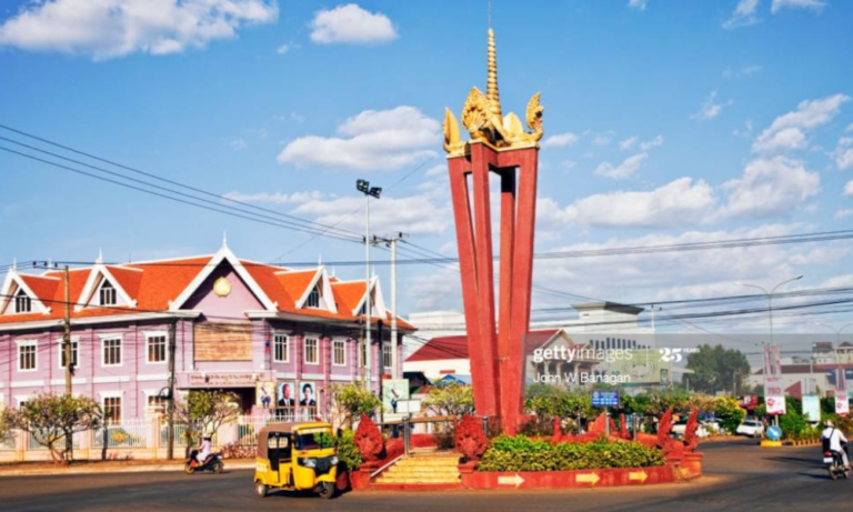
The Khmer Leu hill tribe regards the lake as sacred, believing it to be home to mystical beings. The surrounding forests are also protected, reflecting the tribe’s commitment to conservation. To visit, head east from Independence Monument for 3 km, then right for 1.5 km to the entrance, where a $1 entrance fee supports the local community.
Geography Of Rattanakiri Province
Ratanakiri boasts a variety of geographical features, including rolling hills, mountains, plateaus, lowland basins, stunning waterfalls, and volcanic crater lakes. The province is traversed by two significant rivers, the Tonlé San and the Tonlé Srepok, which flow from east to west. In the north, the Annamite mountain range stands tall, while fertile basalt plateaus lie between the rivers, and tropical forests flourish in the south, all contributing to the region’s rich ecological diversity. The highlands, where most of Ratanakiri’s residents live, are marked by rolling basalt plateaus with nutrient-rich red soil. Consequently, visitors often find themselves navigating the red dirt roads that wind through this beautiful area.
Ratanakiri is renowned for its vibrant forests that span a large part of the region, creating a thriving environment for remarkable biodiversity. This is why many wildlife lovers and researchers find a trip to Ratanakiri so appealing. The province features dense woodlands, lowland tropical rainforests, and montane forests, all of which showcase some of the richest biodiversity in Southeast Asia. These natural wonders are major attractions for Ratanakiri’s tourism sector, offering activities like forest hikes, trekking, and birdwatching tours where visitors can spot parrots and gibbons in their natural surroundings—definitely among the top experiences in Ratanakiri. Virachey National Park, Norng Kabat Rainforest, and Lumphat Wildlife Sanctuary not only serve as refuges for numerous rare and endangered species but also draw tourists eager to immerse themselves in the beauty of nature.
Population and Climate
There are eight distinct hill tribes and ethnic groups residing in Ratanakiri. Most of these communities inhabit the remote jungles, hills, and mountainous regions, living in small, isolated villages. Their livelihoods primarily depend on traditional farming methods, such as shifting agriculture, along with hunting and foraging for fruits in the forest. These ancient cultures hold a strong belief in spirits, rooted in their animistic traditions. The province is home to a total population of 128,107, comprising 63,333 males and 64,774 females, which translates to a density of 11.8 inhabitants per square kilometer.
Ratanakiri Province experiences a climate similar to other regions in the country, characterized by three distinct seasons: the rainy season from June to October (with temperatures below 27°C), the cool season from November to February (with temperatures above 24°C), and the hot season from March to May (with temperatures ranging from 20°C to 32°C). Overall, Ratanakiri’s average temperature is cooler than in most other parts of Cambodia, except Mondulkiri Province.
Economy Rattanakiri Province
Most of the indigenous communities in Ratanakiri engage in subsistence farming, cultivating crops like rice, corn, and pumpkins. Some also grow additional crops such as peanuts or cashews. Surrounding the capital of Banlung, there are several affluent Cambodians and Vietnamese who own extensive plantations, primarily growing peanuts, coffee, and cashews.
Ratanakiri is also home to vast rubber plantations, with much of the rubber being exported to neighboring Vietnam. The ongoing reconstruction of Cambodian National Highway 19, which passes through Banlung, is expected to boost trade with Vietnam. However, Ratanakiri remains sparsely populated, resulting in the provincial capital lacking a robust market compared to other regions in Cambodia. In terms of mineral resources, Ratanakiri is rich in gold, gemstones, granite, and onyx. The area is blessed with fertile red soil, abundant water sources, diverse wildlife, and high-quality hardwoods, along with beautiful weather and scenery that enhance its appeal.
Rattanakiri Province Airport
Banlung features an airfield right in the town, but unfortunately, all commercial airlines have ceased operations in Ratanakiri. The only flights that used to operate were with Mission Aviation Fellowship, utilizing an 8-seater aircraft, but those services ended in late 2009. For medical evacuations and charter flights, Helicopters Cambodia is available. At present, the runway in Banlung remains a gravel strip, but there are intentions to expand it and construct a concrete runway. This upgrade could potentially draw in a new airline and reduce the number of cancellations during the rainy season.
Taxi, Bus or Vans
Numerous bus companies, including Giant Ibis, Mekong Express, PSD Xpress, Sorya Bus, Neak Krohorm, Thero Express (15-seat), Larryta, KSO, Virak Buntham, and Cambodia Post VIP Van, provide transportation services to Rattanakiri. These companies operate modern, air-conditioned buses and vans, with departures scheduled every 15 minutes to one hour from 6 AM to midnight. The fares are quite reasonable, and online bus tickets can be purchased in advance.
Share/Private Taxi
A more expensive option than the bus, taking a private taxi from Phnom Penh to Banlung is possible, for about US$120. It’s a 5-6 hour drive to the junction near Stung Treng, then 2 hours to Banlung, plus meal breaks.
Check available flight below:
Things to see & Do in Rattanakiri Province

Where to Stay in Rattanakiri Province (Suggestion)
1. Terres Rouges Lodge [ Book Now ]
St 422, Phum Tes Anlong Sanghat Beung Kansaign, Banlung, Ratanakiri Province
2. Yeak Loam Hotel [ Book Now ]
Street 29, Krong Ban Lung, Ratanakiri Province
3. Ratanakiri Paradise Hotel & Restaurant [ Book Now ]
Loun Village, Yeak Laom, Krong Banlung 3 km on road from Yeak Laom Lake to Ou’Sean Lair, Yeak Laom, Ratanakiri Province
Check available Hotel below:
Popular Tours of Rattanakiri Province
Phnom Penh Private Tour: 1 Day Tour
Explore the vibrant city of Phnom Penh with a private tour that allows you to customize your itinerary based on your interests. Experience the rich culture, history, and beauty of Cambodia with a personalized guided tour.
There are no reviews yet.